Depression intensifies into Cyclonic storm 'Yaas' over east-central Bay of Bengal
By :
Notice: Trying to get property 'fName' of non-object in /home/u589520015/domains/observerdawn.com/public_html/module/Application/view/application/index/news.phtml on line 23
Notice: Trying to get property 'lName' of non-object in /home/u589520015/domains/observerdawn.com/public_html/module/Application/view/application/index/news.phtml on line 23
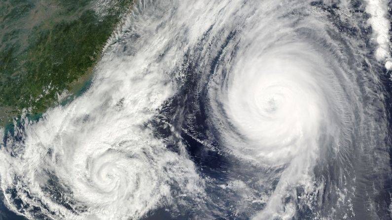
The deep depression over East Central Bay of Bengal has intensified into Cyclonic Storm ‘Yaas’ over East Central Bay of Bengal, IMD sources here today.
The Deep Depression over East Central Bay of Bengal remained practically stationary during past 6 hours, intensified into Cyclonic Storm ‘Yaas’ and lay centred at about 600 km north-northwest of Port Blair , 540 km south-southeast of Paradip (Odisha), 650 km south-southeast of Balasore (Odisha) and 630 km south-southeast of Digha (West Bengal).
It is very likely to move slowly north-northwestwards, intensify further into a Severe Cyclonic Storm during next 24 hours and into a Very Severe Cyclonic Storm during subsequent 24 hours.
Met sources said it would continue to move north-northwestwards, intensify further and reach Northwest Bay of Bengal near north Odisha and West Bengal coasts by 26th May early morning.
It is very likely to cross north Odisha-West Bengal coasts between Paradip and Sagar islands around noon of May 26th as a Very Severe Cyclonic Storm.
IMD sources said the gale wind speed reaching 60–70 kmph gusting to 80 kmph prevailing over West Central adjoining Eastcentral Bay of Bengal.
It is very likely to increase further becoming Gale wind speed reaching 80 to 90 gusting to 100 kmph over major parts of central Bay of Bengal by May 24 evening and would decrease gradually thereafter.
Squally wind speed reaching 40-50 kmph gusting 60 kmph is very likely to prevail over North Bay of Bengal and adjoining west central Bay of Bengal along and off Odisha–West Bengal coasts from May 24 afternoon.
It would increase gradually becoming 50-60 kmph gusting to 70 kmph from May 25 evening and would further increase becoming gale wind speed 60-70 kmph gusting to 80 kmph from May 26 early hours over northwest Bay of Bengal and along and off West Bengal & north.
It would gradually increase further becoming 90-100 gusting to 110 kmph from May 26 morning and increase thereafter becoming 155-165 kmph gusting to 180 kmph at the time of landfall.
Squally wind speed reaching 55-65 kmph gusting to 75 kmph likely over north interior districts of Odisha during 26th evening to 27th morning.
The Sea conditions would be high to very high over West Central & adjoining east central Bay of Bengal. It is very likely to become gradually very high to phenomenal over northern parts of central Bay of Bengal, North Bay of Bengal and along & Odisha–West Bengal coasts during May 24 to May 26.
The fishermen are advised not to venture into the deep sea area of central Bay of Bengal from May 24 – May 25 and into North Bay of Bengal along & off Odisha coast from May 24 to May 27.
Meanwhile, the Local Cautionary Signal No. 3 (LC- 3) has been replaced by Local Warning Signal No. 4 (LW-4) at Paradip and Dhamra Ports and Local Cautionary Signal No. 3 (LC- 3) has been kept at Gopalpur and Puri Ports of Odisha.
The Paradip Port authority has started vacating the ships anchored at the berths since 8 AM this morning to safer places. All other ships anchored close the the post have been advised to move to the safer places as the very severe cyclonic storm likely to make landfall on May 26 afternoon between Paradip and Sagar Island.